Sources

Records


image.png

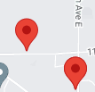
Record source files are a JSON formatted array of objects with each object containing at minimum a lat and lng key. Each record is attached to a marker which is placed on the map according to the latitude (lat) and longitude (lng) keys. Any other arbitrary properties and values can be included in each record.


[
  {
    "First Name":"John",
    "Last Name":"Smith",
	...
    "lat":"47.204935",
    "lng":"-122.237967"
  },
  {
    "First Name":"Jane",
	"Last Name":"Doe",
    ...
    "lat":"47.204157",
	"lng":"-122.231124"
  }
]


Skyward typically exports data in CSV format, however there are many free online tools which can convert CSV files to JSON. The Technology Services department can perform bulk geocoding of addresses if needed.

CSV JSON
First Name,Last Name,lat,lng
John,Smith,47.204935,-122.237967
Jane,Doe,47.204157,-122.231124
[
  {
    "First Name":"John",
    "Last Name":"Smith",
    "lat":"47.204935",
    "lng":"-122.237967"
  },
  {
    "First Name":"Jane",
	"Last Name":"Doe",
    "lat":"47.204157",
	"lng":"-122.231124"
  }
]


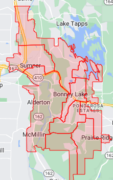
GeoJSON


image.png A GeoJSON source is a file which defines geospatial features (e.g school boundaries) in the GeoJSON format. A repository of optimized SBLSD boundary files can be downloaded from github.com/sblsd/gis.